You should spend about 20 minutes on this task.
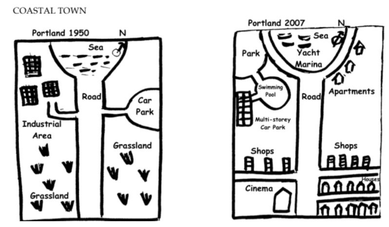
The diagram below shows the changes, which took place in a coastal area called Pentland from 1950 to 2007. Write a report for a university lecturer describing the diagrams below.

The given diagram shows the changes, which occurred in a coastal town, Pentland, between 1950 and 2007. It can be seen that the area developed a lot in the given period of 57 years.
In 1950, Pentland was located towards the south of the sea. There was a straight main road bisecting the town into two. Two side roads were there, one to the left and the other to the right. The left road led to an industrial area, whereas the right one led to the car park. The rest of the area was mainly grassland.
57 years later, the sea was developed as a Yacht Marina, circled by a newly built road, which was linked to the original straight road. Many apartments were built to the right. The industrial area on the left was replaced by a park, a swimming pool and a multi-storey car park. The side roads were shifted further southwards. The car park on the right was removed and many apartments were built in its place. On the south-east corner of Pentland, many houses were built and a cinema was constructed in the corner between the main road and the left side road. Many shops were opened along the northern side of both side roads.
Overall, Pentland developed into a busy commercial coastal town over a period of half century.
下图显示了沿海城市Pentland在1950年至2007年间发生的变化。可以看出,在57年的时间里,该地区有了很大的发展。
1950年,Pentland位于海的南部。有一条笔直的主干道将小镇一分为二。两条支路,一条在左边,另一条在右边。左边的路通往工业区,而右边的路则通往停车场。其余地区主要是草原。
57年后,海边被开发成了游艇码头,被一条新建的道路圈起来,与原来的直路相连。右边建了许多公寓。左边的工业区,被一个公园、一个游泳池和一个多层停车场所取代。边上的道路进一步向南移动。右边的停车场被拆除,取而代之的是许多公寓。在Pentland的东南角,建造了许多房屋,并在主干道和左侧侧路之间的角落里建造了一家电影院。沿着两条侧路的北侧,开设了许多商店。
总的来说,Pentland在半个世纪的时间里,发展成为一个繁忙的沿海商业城市。


